What do diplomacy and geometry have in common? Apparently, nothing. However, with a square and a ruler in hand, borders have been delineated. And, as in the case at hand, negotiation spaces have also been drawn, as occurred in 1659 on the Pheasant Island, on the Spanish-French border marked by the Bidasoa River.
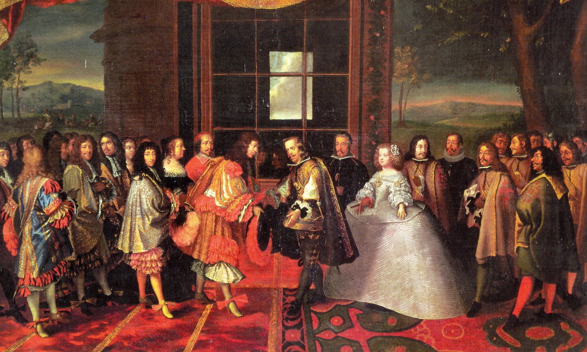
Mid-October 1659. In the context of the Thirty Years’ War, Spain and France negotiate the end of the hostilities that have bled them since 1635. The favorite of Philip IV, the 4th Count-Duke of Olivares, Luis Méndez de Haro, sits across from Cardinal Jules Mazarin, chief minister of Louis XIV, after ensuring that the table they share rests on the exact midpoint of the island of the Pheasants —also known as “of the Conference” or “of the Diplomats”— “so that it would not seem that a prime minister of Spain was negotiating peace outside his territory.”
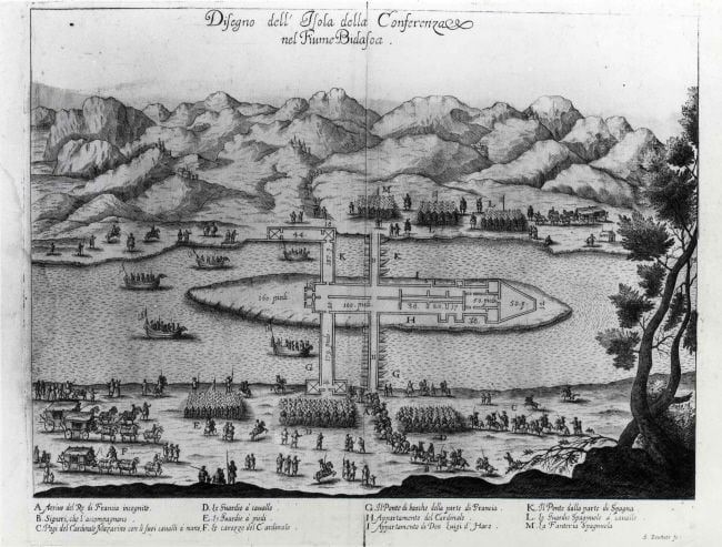
The plans drawn up at that time demonstrate the precision that both parties put into delineating the territories and building the pavilions where the end of what many historians have considered the first true world war —long before that of 1914-1918— was negotiated, involving all European powers in practically every corner of the planet.
Méndez de Haro’s argument was not a mere whim. The French kings, under pressure from the fishermen of Hendaya, always tried to seize any opportunity to claim their sovereignty over half of the Bidasoa. But they always received the same response from the Spanish side: everything that the water covered belonged to Spain. Enrique IV told Luis XI this for the first time in 1463. And the Frenchman had to respond: “You speak the truth.” End of the story, for now.
In 1659 the balance of power in Europe was changing, but the Island of the Pheasants remained in the same place. And King Louis XIV continued to bear the pressure from the fishermen of Hendaya to solve their problem, now taking advantage of his position of strength against Spain.
The Island of the Pheasants, however, was undoubtedly “Spanish” in the eyes of the inhabitants of Hondarribia, whose representatives made the French side sign a document stating that the Island belonged to that town and that its use was granted at that moment only “temporarily for such a relevant act.” In any case, no one lost sight of the fact that any concession regarding the island would have consequences for delineating where French and Spanish boats could fish.
On November 7 of that year, after 24 meetings, Méndez de Haro and Mazarin, each on their side of the island, signed the Treaty of the Pyrenees. The following year, it was the monarchs of both countries, Louis XIV and Philip IV, who personally ratified the 124 agreements, and another 8 ‘secret’ articles, meeting in the pavilion “made on the Island called of the Pheasants, located in the Bidasoa River, half a league from the Place of Andaya in the Province of Guiena, and the same distance from Irún, Province of Guipúzcoa, in the House built on said Island for the present Treaty, on November 7, 1659.”
In summary, distances and details mattered a lot, although in some cases exceptions had to be made. The bridges specifically established for the passage of kings and their retinues also followed strict rules, although allowing the French bridge to have some more barges, given that the distance to their shore was greater than that separating the island from Spain. But only that.
Returning to the ‘secret articles’, two particularly important ones stand out: the fifth, which establishes the marriage of Infanta María Teresa to King Louis XIV, which will ultimately be the cause of the end of the Habsburgs on the Spanish throne; and the eighth, which provides for the appointment of a commission to resolve the sovereignty differences that had pitted the cities of Hendaya and Hondarribia against each other for centuries.
While the royal wedding took place without major problems that same day, the fact is that not even the famous eighth article could make Spain yield to Louis XIV’s claims. Disputes over the ownership of the river would extend for almost two more centuries, until 1856, when both parties signed the first of the Boundary Treaties —or of Bayonne— which set the borders along the territories of Guipúzcoa and Navarra.
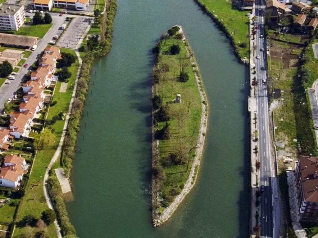
There begins the modern history of an island that, due to its lack of population, does not even have pheasants, despite its name. There were none then, and there are none now. In reality, the name is a translation error. Originally called Isla de Pausu —in Basque, the “pass” where tolls were collected— the name evolved to Paussans —those who pass— and from there the French reinterpreted it as Faussans and later as Faisans, which in Spanish was logically translated as Faisanes. No one asked questions, and everyone accepted a name that was certainly false, but prettier.
The Treaty of 1856 ended the disagreements over the sovereignty of the Bidasoa and the Island of the Pheasants itself. Article 27 established that “it will belong pro indiviso to Spain and France”, which made it the smallest condominium in the world. It also set the limit as the center of the main current of the river at low tide and allowed navigation without distinctions throughout the river, eliminating the old clause that prohibited the French from fishing with keel boats.
Uninhabited and measuring barely 80 meters long and 5 wide, at that time the historic island seemed doomed to disappear. But the governments of the time, those of Isabel II and Napoleon III, committed to carrying out the necessary works for its conservation. A custom that is still maintained and whose responsibility falls on the municipalities of Irún and Hendaya.
Currently, the islet measures 224 by 41 meters and is dominated by a monolith commemorating the Treaty of Bayonne, with the text in French facing north and in Spanish facing south. In its current 7,000 square meters, no one is allowed to enter. Only the gardeners of Irún and Hendaya, who take care of its cleaning, and the military from the respective naval commands, who every 6 months —February 1 and August 1— carry out the official transfer ceremony, are allowed in.
Of course, no type of construction is allowed on the island. It seems like a truism, but it happened in 1609. The then Lord of Urtubia wanted to seize the island and began to make some works on it, until he found that the neighbors of Hondarribia, arms in hand, forced him to desist. A warning to sailors, just in case.